Marine Weather Warnings
NOAA’s National Weather Service (NWS) issues marine weather watches, advisories, and warnings for hazardous winds and sea conditions. In addition, NWS issues watches, warnings, and advisories for other hazards to mariners including dense fog and freezing spray conditions and special marine warnings for potentially hazardous marine weather conditions, usually of short duration (i.e. high winds and large hail during thunderstorms or waterspouts). Finally, advisory products for tropical storms and hurricanes are provided by NOAA’s National Hurricane Center and Central Pacific Hurricane Center, depending on where the storm is located (Atlantic and eastern North Pacific, or central North Pacific, respectively).
A watch informs mariners when a significant or hazardous weather event is possible, but not imminent during the next 12 to 36 hours. An advisory indicates that a hazardous weather event is coming, imminent, but does not meet warning criteria. A warning alerts mariners that a significant or hazardous weather event is likely, imminent, or occurring, and is a threat to life and property.
The NWS also issues weather statements to provide mariners with details on significant or potentially hazardous conditions not otherwise covered in existing marine warnings and forecasts as well as risk assessments for rip currents and other beach hazards.
Detailed information about marine weather watches, advisories, and warnings can be found here.
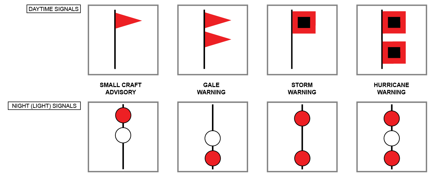
Coastal warning display (CWD) flags and signals.
Note: Not all coastal locations fly these flags. NWS retired its coastal warning display program in 1989 but in 2007, the U.S. Coast Guard re-established the CWD program at selected small boat stations.
The latest marine weather watches, advisories, and warnings for the U.S. can be found at NOAA’s nowCOAST™.

Contiguous U.S.

Great Lakes

Alaska

Pacific Islands

Puerto Rico and U.S. Virgin Islands
Guide to Marine Weather Watches, Advisories, and Warnings
Small Craft Advisory
An advisory issued to alert mariners to sustained winds and/or sea conditions, either present or forecast, that might be hazardous to small craft. A Small Craft Advisory may also be issued when sea or lake ice exists that could be hazardous to small boats. There is no precise definition of a small craft. Any vessel that may be adversely affected by Small Craft Advisory criteria should be considered a small craft. Other considerations include the experience of the vessel operator, and the type, overall size, and seaworthiness of the vessel. The general threshold is sustained winds between 20 to 33 knots but a sea/wave threshold ranges from 4 to 10 feet or greater. The wind and sea condition thresholds governing the issuance of small craft advisories are specific to geographic areas:
- Eastern (Maine to South Carolina, Lake Erie, Lake Ontario) - sustained winds or frequent gusts ranging between 25 and 33 knots (except 20 to 25 knots, lower threshold area dependent, to 33 knots for harbors, bays, etc.) and/or seas or waves 5 to 7 feet and greater, area dependent.
- Central (Minnesota to Ohio) - sustained winds or frequent gusts (on the Great Lakes) between 22 and 33 knots inclusive, and/or seas or waves greater than 4 feet.
- Southern (Georgia to Texas and Caribbean) - sustained winds of 20 to 33 knots, and/or forecast seas 7 feet or greater that are expected for more than 2 hours.
- Western (Washington to California) - sustained winds of 21 to 33 knots, and/or wave heights exceeding 10 feet (or wave steepness values exceeding local thresholds).
- Alaska - sustained winds or frequent gusts of 23 to 33 knots. A small craft advisory for rough seas may be issued for sea/wave conditions deemed locally significant, based on user needs, and should be no lower than 8 feet.
- Pacific (Hawaii, Guam, etc) - sustained winds 25 knots or greater and seas 10 feet or greater; except in Guam and the northern Mariana Islands where sustained winds are 22 to 33 knots and/or combined seas of 10 feet or greater.
Note: "frequent gusts" are typically long duration conditions (greater than 2 hours).
Brisk Wind Advisory
A Small Craft Advisory issued for ice-covered waters.
Gale Watch
A watch for an increased risk of a gale force wind event for sustained surface winds, or frequent gusts, of 34 knots (39 mph) to 47 knots (54 mph), but its occurrence, location, and/or timing is still uncertain, and not directly associated with a tropical cyclone—not issued for offshore waters and high seas.
Gale Warning
A warning of sustained surface winds, or frequent gusts, in the range of 34 knots (39 mph) to 47 knots (54 mph) inclusive, either predicted or occurring, and not directly associated with a tropical cyclone.
Storm Watch
A watch for an increased risk of a storm force wind event for sustained surface winds, or frequent gusts, of 48 knots (55 mph) to 63 knots (73 mph), but its occurrence, location, and/or timing is still uncertain, and not directly associated with a tropical cyclone.
Storm Warning
A warning of sustained surface winds, or frequent gusts, in the range of 48 knots (55 mph) to 63 knots (73 mph) inclusive, either predicted or occurring, and not directly associated with a tropical cyclone.
Hurricane Force Wind Watch
A watch for an increased risk of a hurricane force wind event for sustained surface winds, or frequent gusts, of 64 knots (74 mph) or greater, but its occurrence, location, and/or timing is still uncertain, and not directly associated with a tropical cyclone.
Hurricane Force Wind Warning
A warning for sustained winds, or frequent gusts, of 64 knots (74 mph) or greater, either predicted or occurring, and not directly associated with a tropical cyclone.
Hurricane Watch
An announcement that hurricane conditions (sustained winds of 74 mph or higher) are possible within the specified coastal area. Because hurricane preparedness activities become difficult once winds reach tropical storm force, the hurricane watch is issued 48 hours in advance of the anticipated onset of tropical-storm-force winds.
Hurricane Warning
An announcement that hurricane conditions (sustained winds of 74 mph or higher) are expected somewhere within the specified coastal area. Because hurricane preparedness activities become difficult once winds reach tropical storm force, the hurricane warning is issued 36 hours in advance of the anticipated onset of tropical-storm-force winds.
Tropical Storm Watch
An announcement that tropical storm conditions (sustained winds of 39 to 73 mph) are possible within the specified coastal area within 48 hours.
Tropical Storm Warning
An announcement that tropical storm conditions (sustained winds of 39 to 73 mph) are expected somewhere within the specified coastal area within 36 hours.
Hazardous Sea Watch
A watch for an increased risk of a hazardous seas warning event to meet Hazardous Seas Warning criteria but its occurrence, location, and/or timing is still uncertain.
Hazardous Sea Warning
A warning for wave heights and/or wave steepness values meeting or exceeding locally defined warning criteria.
Beach Hazards Statement
Informs beachgoers and local authorities to a multitude of hazards including, but not limited to, the following: rip currents (or other types of dangerous currents in the surf zone), unusually cold water temperatures, potential for lightning along the beach/shoreline, or unusual surf/wave conditions which do not meet advisory criteria. In coordination with other agencies (as needed), the product may also inform users of various types of environmental hazards (e.g. chemical spills, harmful algal blooms, high bacteria levels in the water, or potentially hazardous marine wildlife which may be impacting the area). It is used to describe hazards that do not meet NWS advisory, watch, or warning criteria, as well as hazards that do not have advisory, watch, or warning criteria (e.g. rip currents, oil spills). The statement is issued using the Coastal Hazard Message.
Rip Current Statement
Informs beachgoers and local authorities of a high threat of rip currents due to weather and ocean conditions. The statement usually contains some detail about when and roughly where the rip currents are most likely to be forming (e.g. east facing beaches) and how long the conditions are likely to continue. The statement is issued using the Coastal Hazard Message.
High Surf Advisory
A High Surf Advisory is issued when breaking wave action poses a threat to life and property within the surf zone. High surf criteria varies by region. High Surf Advisories are issued using the Coastal Hazard Message.
High Surf Warning
A High Surf Warning is issued when breaking wave action results in an especially heightened threat to life and property within the surf zone. High surf criteria varies by region. High Surf Warnings are issued using the Coastal and Lakeshore Hazard Message.
Low Water Advisory
An advisory to describe water levels which are significantly below average levels over the Great Lakes, coastal marine zones, and any tidal marine area, waterway, or river inlet within or adjacent to a marine zone that would potentially be impacted by low water conditions creating a hazard to navigation.
Dense Fog Advisory
An advisory for widespread or localized fog reducing visibility to regionally or locally defined limitations not to exceed one nautical mile.
Freezing Spray Advisory
An advisory for an accumulation of freezing water droplets on a vessel at a rate of less than two centimeters (cm) per hour caused by some appropriate combination of cold water, wind, cold air temperature, and vessel movement.
Heavy Freezing Spray Watch
A watch for an increased risk of a heavy freezing spray event (rate of two cm per hour or greater) but its occurrence, location, and/or timing is still uncertain.
Heavy Freezing Spray Warning
An accumulation of freezing water droplets on a vessel at a rate of 2 cm per hour or greater caused by some appropriate combination of cold water, wind, cold air temperature, and vessel movement.