Nautical Charts
Find Nautical Charts
NOAA has been producing the nation's nautical charts for nearly two centuries and electronic charts since the early 1990s. Specifically tailored to the needs of marine navigation, nautical charts delineate the shoreline and display important navigational information, such as water depths, prominent topographic features and landmarks, and aids to navigation. They represent one of the most fundamental tools available to mariners.
Electronic Navigational Charts
NOAA electronic navigational charts (NOAA ENC®) are NOAA's primary nautical chart product. Originally designed for large commercial vessels using a sophisticated navigational computer called an electronic chart display and information system (ECDIS), ENCs are now also used on simpler navigation systems on many types of ships and by recreational boaters.
NOAA ENCs are vector data sets that support all types of marine navigation. They hold all of the navigational information associated with traditional nautical charts, while also facilitating real-time ship positioning and helping with collision and grounding avoidance. The benefits of ENCs include: being easy to update, utilizing layers that can be turned on and off to reduce cluttered displays, and remaining correctly oriented at all times. ENCs also enable navigation systems to automatically alert mariners when a ship is diverging from its planned course or heading toward shallow water or other dangers, making navigation even safer for the modern mariner.
NOAA ENCs cover over 95,000 miles of shoreline and 3.6 million square nautical miles of U.S. ocean, coastal, and Great Lakes waters to the outer limits of the U.S. Exclusive Economic Zone. NOAA ENCs comply with the International Hydrographic Organization ENC Product Specifications. The U.S. Army Corps of Engineers produces Inland ENCs for many U.S. rivers.
Individual ENCs can be downloaded from the NOAA Chart Locator. Groups of ENCs may be downloaded by region, such as by state or coast guard district from the ENC download page. ENCs downloaded directly from these Coast Survey websites are free. NOAA ENCs may also be obtained from the International Centre for Electronic Navigational Charts, or IC-ENC, through a value added reseller. IC-ENC charges a fee for this service.
Updates for ENCs
NOAA continually updates ENCs with data from a variety of sources and new ENC update cells are uploaded every weekday evening. Updates include critical changes, such as changes to aids to navigation (buoys, beacons and lights) or newly discovered shoals; as well as the routine addition of newly compiled data, such as hydrographic or shoreline surveys. The NOAA Navigation Updates webpage shows the location and type of changes that have occurred.
ENC Derived Paper Charts
The NOAA Custom Chart (NCC) application enables users to create customized paper charts directly from the latest NOAA ENC data. Users can create, customize and print paper charts themselves. Depths can be displayed in meters, feet, or fathoms and there are a few other display options, such as changing the depth at which a shallow water blue tint is applied and the depiction of a "safety contour" based on a vessel's draft. More information about the application is on the NOAA Custom Chart page.
End of Traditional NOAA Paper Nautical Chart Production
NOAA has discontinued maintenance and production of traditional paper nautical charts to focus efforts on improving its electronic navigational charts. All traditional NOAA paper nautical charts have been cancelled and the U.S. Coast Guard is no longer issuing notices to mariners chart corrections for them.
ENC Rescheming
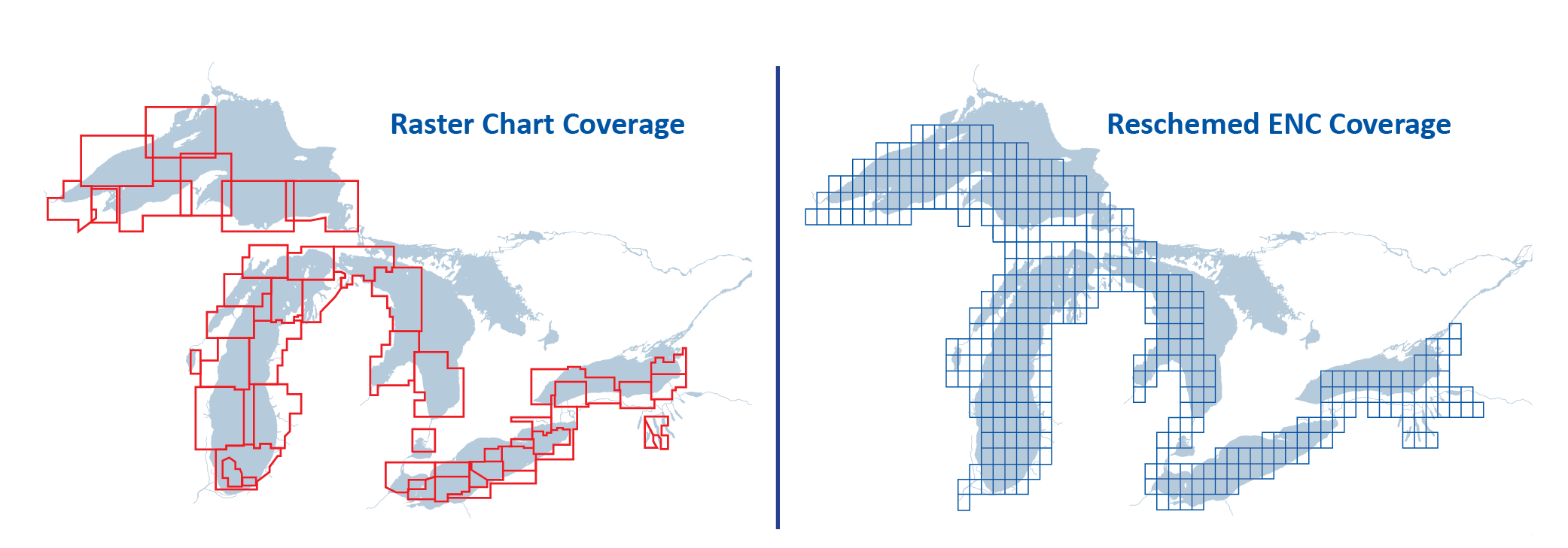
The arrangement or layout of a set of charts is called a scheme — a systematic configuration of chart "footprints". NOAA is creating a new gridded layout of rectangularly shaped charts for its electronic navigational chart product suite.
In the early 1990s, NOAA began digitizing data from its paper nautical charts to create content for a new digital chart product, the electronic navigational chart. The scale and limits of each ENC chart (called a cell) were inherited directly from its corresponding paper chart. The resulting ENC product suite consisted of over 1200 irregularly shaped ENC cells, compiled in over 100 different scales. The new scheme will ultimately comprise over 7,000 cells in only 12 standard scales. New ENC cells each cover smaller footprints and are often compiled at a larger (more detailed) scale than the ENCs that they replace.
Below, the original layout of the "approach scale" ENCs in the Great Lakes is shown in red. The new gridded scheme for the same coverage is shown in blue.
The new scheme for all NOAA ENCs may be seen on the Status of New NOAA ENCs webmap, which also shows the ongoing progress of creating reschemed ENCs.
As new gridded ENCs are created, a number of improvements to the quality and consistency of the data are being implemented:
- Larger, standard scale coverage
- Standardized metric depth contours
- Resolution of discontinuities between adjacent ENCs
More information can be found on the Rescheming and Improving Electronic Navigational Charts webpage.

